Category:Llanddeusant, Carmarthenshire
Jump to navigation
Jump to search
village and community in Carmarthenshire, Wales  L'église de Llanddeusant. | |||||
| Upload media | |||||
| Pronunciation audio | |||||
|---|---|---|---|---|---|
| Instance of | |||||
| Location | Carmarthenshire, Wales | ||||
| Mountain range | |||||
| Population |
| ||||
| Area |
| ||||
 | |||||

Cymraeg: Mae pentref Llanddeusant, Sir Gaerfyrddin wedi ei leoli ar ymyl orllewinol Parc Cenedlaethol Bannau Brycheiniog, ger Llangadog, a ger afon Sawdde. Mae yna boblogaeth sylweddol o Farcudiaid Coch yn yr ardal ac un o atyniadau'r pentref yw'r Orsaf Fwydo Barcudiaid sydd ar agor i'r cyhoedd. Mae hostel ieuenctid yn ei lleoli yn y pentref.
English: Llanddeusant is a small village (in the community of the same name) located in the Brecon Beacons, Carmarthenshire, Wales.
Media in category "Llanddeusant, Carmarthenshire"
The following 200 files are in this category, out of 386 total.
(previous page) (next page)-
 A dam on the stream - geograph.org.uk - 4791755.jpg 640 × 480; 91 KB
-
 A distant Llyn y Fan Fach - geograph.org.uk - 3622229.jpg 1,600 × 1,200; 559 KB
-
 A lane near Llanddeusant in June - geograph.org.uk - 2456103.jpg 640 × 480; 109 KB
-
 A sea of stones - geograph.org.uk - 1096675.jpg 640 × 480; 112 KB
-
 A4069 at Pont Aber - geograph.org.uk - 4671376.jpg 640 × 480; 84 KB
-
 Aber Nant Ty Bach confluence - geograph.org.uk - 3913287.jpg 640 × 480; 83 KB
-
 Aberdeudwrch - geograph.org.uk - 2454361.jpg 690 × 518; 204 KB
-
 Above Ty-uchaf - geograph.org.uk - 2015735.jpg 640 × 428; 236 KB
-
 Afon Llechach at Tomen Llechach - geograph.org.uk - 1086359.jpg 640 × 480; 104 KB
-
 Afon Mihartach, Llanddeusant - geograph.org.uk - 3592702.jpg 690 × 518; 195 KB
-
 Afon Sawdde - geograph.org.uk - 6228917.jpg 3,264 × 2,448; 3.65 MB
-
 Afon Sawdde - geograph.org.uk - 6236643.jpg 2,048 × 1,536; 989 KB
-
 Afon Sawdde descending from Llyn y Fan Fach - geograph.org.uk - 3923393.jpg 1,427 × 1,500; 2.11 MB
-
 Afon Sawdde, descending - geograph.org.uk - 3923410.jpg 1,500 × 1,097; 2.03 MB
-
 Afon Wysg-River Usk - geograph.org.uk - 2949070.jpg 1,024 × 680; 256 KB
-
 Approaching Picws Du - geograph.org.uk - 6236655.jpg 1,536 × 2,048; 1.22 MB
-

-

-
 Bannau Sir Gaer - geograph.org.uk - 2128196.jpg 640 × 480; 82 KB
-
 Bannau Sir Gaer - geograph.org.uk - 2953258.jpg 1,024 × 680; 219 KB
-
 Bannau Sir Gaer - geograph.org.uk - 6237246.jpg 9,202 × 2,955; 7.83 MB
-
 Bannau Sir Gaer - Picws Du - geograph.org.uk - 3298297.jpg 1,600 × 1,200; 957 KB
-
 Bannau Sir Gaer - Picws Du 2760' - 749m - geograph.org.uk - 5973721.jpg 1,080 × 810; 133 KB
-
 Bannau Sir Gaer in summer - geograph.org.uk - 2569520.jpg 640 × 480; 79 KB
-
 Bannau Sir Gaer seen from the north - geograph.org.uk - 3171916.jpg 1,800 × 600; 147 KB
-
 Bannau Sir Gar as seen from Carmarthen - geograph.org.uk - 4932611.jpg 1,440 × 1,080; 240 KB
-
 Bothy and dam overflow - geograph.org.uk - 6228998.jpg 3,264 × 2,448; 2.56 MB
-
 Boulders on east side of Garreg Las - geograph.org.uk - 3922292.jpg 1,500 × 1,125; 1.38 MB
-
 Bridge crossing a leat - geograph.org.uk - 2949665.jpg 1,024 × 680; 237 KB
-
 Bridge over Afon Llechach - geograph.org.uk - 4362872.jpg 640 × 480; 110 KB
-
 Bridge over Afon Sawdde - geograph.org.uk - 6228738.jpg 3,264 × 2,448; 2.52 MB
-
 Bridleway crossing Twrch Fechan - geograph.org.uk - 2953270.jpg 1,024 × 680; 238 KB
-
 Bryn Cedni - geograph.org.uk - 3915644.jpg 640 × 480; 67 KB
-
 Bryn Elen - geograph.org.uk - 3913276.jpg 640 × 480; 81 KB
-
 Bryn yr Wyn - geograph.org.uk - 2949312.jpg 1,024 × 680; 169 KB
-
 Cairn on Bannau Sir Gaer - geograph.org.uk - 2954844.jpg 1,024 × 680; 239 KB
-
 Cairn on Picws Du - geograph.org.uk - 2107251.jpg 1,600 × 1,200; 489 KB
-
 Careg Yr Ogof - geograph.org.uk - 3298346.jpg 1,566 × 1,152; 1.07 MB
-
 Carn y Gigfran - geograph.org.uk - 3154917.jpg 2,288 × 1,712; 726 KB
-
 Carnau'r Garreg Las - geograph.org.uk - 3920255.jpg 640 × 480; 85 KB
-
 Carnau'r Garreg Las - geograph.org.uk - 6367223.jpg 1,024 × 767; 221 KB
-
 Carnau'r Garreg Las - geograph.org.uk - 6367226.jpg 1,024 × 768; 154 KB
-
 Carnau'r Garreg Las Cairns 1 ^ 2 - geograph.org.uk - 4221348.jpg 640 × 480; 59 KB
-
 Carreg yr Ogof - geograph.org.uk - 3594744.jpg 690 × 518; 161 KB
-
 Carreg yr Ogof - geograph.org.uk - 6367205.jpg 1,024 × 768; 181 KB
-
 Carreg yr Ogof - geograph.org.uk - 6367210.jpg 1,024 × 767; 215 KB
-
 Carreg yr Ogof - geograph.org.uk - 6367217.jpg 1,024 × 768; 223 KB
-
 Cattle Grid - geograph.org.uk - 383844.jpg 640 × 425; 141 KB
-
 Cattle grid - geograph.org.uk - 532276.jpg 600 × 450; 95 KB
-
 Cattle grid - geograph.org.uk - 6123732.jpg 3,264 × 2,448; 2.27 MB
-
 Cattle grid sign - geograph.org.uk - 6123728.jpg 2,448 × 3,264; 2.41 MB
-
 Cefn Bryn y Fuwch - geograph.org.uk - 3918736.jpg 640 × 441; 89 KB
-
 Cefn Bryn y Fuwch - geograph.org.uk - 6237283.jpg 6,662 × 2,943; 5.17 MB
-
 Clydach valley in the Brecon Beacons - geograph.org.uk - 6039772.jpg 800 × 517; 113 KB
-
 Coming downhill - geograph.org.uk - 4521768.jpg 4,608 × 3,456; 2.26 MB
-
 Complex of ruined walls on north side of stream - geograph.org.uk - 3923439.jpg 1,500 × 1,125; 2.2 MB
-
 Cottages, Llanddeusant - geograph.org.uk - 3666883.jpg 1,024 × 683; 694 KB
-
 Country road - geograph.org.uk - 6123469.jpg 3,264 × 2,448; 3.04 MB
-
 Cross Inn - geograph.org.uk - 22004.jpg 640 × 534; 52 KB
-
 Cwar Du Bach - geograph.org.uk - 5174091.jpg 640 × 480; 62 KB
-
 Cwar Glas - geograph.org.uk - 3293929.jpg 768 × 1,024; 367 KB
-
 Cwar Glas, another perspective - geograph.org.uk - 3293932.jpg 768 × 1,024; 325 KB
-
 Cwm Sychlwch - geograph.org.uk - 6237250.jpg 3,241 × 2,304; 1.58 MB
-
 Cwm Taldrum - geograph.org.uk - 2950301.jpg 1,024 × 680; 236 KB
-

-
 Dewdrops on grass - geograph.org.uk - 6237286.jpg 2,004 × 1,568; 1.62 MB
-
 End of the trail - geograph.org.uk - 397213.jpg 640 × 480; 95 KB
-
 Entrance to Godrewaun - geograph.org.uk - 6123487.jpg 3,264 × 2,448; 3 MB
-
 Fan Brycheiniog - geograph.org.uk - 6229177.jpg 2,835 × 2,123; 1.04 MB
-
 Fan Foel (2500') - geograph.org.uk - 5973716.jpg 1,080 × 810; 144 KB
-
 Fan Foel - geograph.org.uk - 6229186.jpg 3,264 × 2,448; 1.73 MB
-
 Fan Foel - geograph.org.uk - 6237256.jpg 2,046 × 1,536; 520 KB
-
 Fan Foel from Picws Du - geograph.org.uk - 3211923.jpg 2,816 × 2,112; 1.41 MB
-
 Fan Foel summit - geograph.org.uk - 2119531.jpg 1,024 × 768; 219 KB
-
 Fan Foel, and Bannau Sir Gaer - geograph.org.uk - 2949631.jpg 1,024 × 680; 221 KB
-
 Fan Sir Gaer - geograph.org.uk - 6237457.jpg 6,590 × 3,000; 6.23 MB
-
 Farm at Talsarn - geograph.org.uk - 6123725.jpg 3,264 × 2,448; 2.89 MB
-
 Farm road above Gellygron - geograph.org.uk - 3921950.jpg 1,500 × 1,125; 2.19 MB
-
 Farmland at Bylchau Blaenclydach - geograph.org.uk - 6039778.jpg 800 × 555; 107 KB
-
 Farmland in Cwm Taldrum - geograph.org.uk - 2950273.jpg 1,024 × 680; 212 KB
-
 Farmland near Pwll-calch - geograph.org.uk - 2950253.jpg 1,024 × 680; 264 KB
-
 Farmland north of Ty-uchaf - geograph.org.uk - 1889034.jpg 640 × 427; 272 KB
-
 Farmland, Llanddeusant - geograph.org.uk - 3666888.jpg 1,024 × 683; 734 KB
-
 Farmland, Llanddeusant - geograph.org.uk - 3666893.jpg 1,024 × 683; 463 KB
-
 Farmland, Llanddeusant - geograph.org.uk - 3666897.jpg 1,024 × 683; 586 KB
-
 Farmland, Llanddeusant - geograph.org.uk - 3666901.jpg 1,024 × 683; 748 KB
-
 Feeding the Kites, Llanddeusant - geograph.org.uk - 3666899.jpg 1,024 × 683; 722 KB
-
 Fern Deep in the Gritstone Pavement - geograph.org.uk - 4221357.jpg 640 × 480; 100 KB
-
 Ffarm Blaenllechach - Blaenllechach Farm - geograph.org.uk - 3687050.jpg 690 × 518; 209 KB
-
 Ffarm Blaensawdde - Blaensawdde Farm - geograph.org.uk - 4226153.jpg 640 × 432; 84 KB
-
 Ffarm Blaensawdde Farm, Llanddeusant - geograph.org.uk - 3543078.jpg 690 × 518; 209 KB
-
 Ffarm Gorsddu - Gorsddu Farm - geograph.org.uk - 4226174.jpg 640 × 428; 64 KB
-
 Ffarm Llanerch Goch - Llanerch Goch Farm - geograph.org.uk - 3687006.jpg 690 × 518; 259 KB
-
 Ffarm Llwynfron Farm - geograph.org.uk - 3542774.jpg 690 × 518; 193 KB
-
 Ffarm Nant-goch - Nant-goch Farm - geograph.org.uk - 3686979.jpg 690 × 518; 214 KB
-
 Ffarm Stangau Farm - geograph.org.uk - 3761517.jpg 690 × 518; 152 KB
-
 Ffarm Tyle-pengam Farm, Llanddeusant - geograph.org.uk - 3543760.jpg 690 × 518; 251 KB
-
 Ffatri Wlan Ynyswen Woollen Factory - geograph.org.uk - 3668782.jpg 690 × 518; 216 KB
-
 Fferm Nantgwynne - geograph.org.uk - 6123491.jpg 2,048 × 1,536; 936 KB
-

-
 Fforest Fawr Geopark information board - geograph.org.uk - 6228959.jpg 2,920 × 2,190; 2.45 MB
-
 Field access track near Talsarn - geograph.org.uk - 2456030.jpg 640 × 480; 103 KB
-
 Fields from Rhiwiau-uchaf - geograph.org.uk - 653178.jpg 2,310 × 1,251; 757 KB
-
 Filter beds - geograph.org.uk - 6228646.jpg 3,008 × 2,256; 2.21 MB
-
 Footbridge over the Afon Llechach - geograph.org.uk - 2456043.jpg 640 × 480; 133 KB
-
 Footpath between Blaensawdde and Gorsddu - geograph.org.uk - 3923553.jpg 1,500 × 1,125; 2.2 MB
-
 Former Pub near Llannddeusant - geograph.org.uk - 4617029.jpg 640 × 428; 67 KB
-

-
 Garn Fawr Stones - geograph.org.uk - 421455.jpg 640 × 480; 94 KB
-
 Garreg Las (Twyn Swnd) - geograph.org.uk - 3298108.jpg 1,600 × 1,200; 718 KB
-
 Garreg Las - geograph.org.uk - 2953286.jpg 1,024 × 680; 243 KB
-
 Garreg Las - geograph.org.uk - 5200160.jpg 640 × 480; 95 KB
-

-
 Gelli-gynon-fach - geograph.org.uk - 6123587.jpg 3,264 × 2,448; 2.82 MB
-
 Ger - Near Blaenllynfell - geograph.org.uk - 4167889.jpg 640 × 480; 69 KB
-
 Glacial channel - geograph.org.uk - 6237274.jpg 2,048 × 1,536; 952 KB
-
 Godre'r Garreg Las - geograph.org.uk - 5200155.jpg 640 × 480; 87 KB
-
 Gorsddu in the Sawdde valley - geograph.org.uk - 2974290.jpg 1,024 × 680; 245 KB
-
 Grassy ridge, north from Waun Lefrith - geograph.org.uk - 3923371.jpg 1,500 × 1,125; 1.31 MB
-
 Gritstone on Garreg Las - geograph.org.uk - 4221352.jpg 640 × 480; 69 KB
-
 Gutter feeding Llyn-y-Fan Fach - geograph.org.uk - 3943448.jpg 1,024 × 768; 145 KB
-

-
 Hen Heol Tir Paun Old Road - geograph.org.uk - 3670086.jpg 690 × 518; 165 KB
-
 Heol Crych-gwyn - Crych-gwyn road - geograph.org.uk - 3542634.jpg 690 × 518; 267 KB
-
 Heol Llyn y Fan Road - geograph.org.uk - 3918747.jpg 640 × 630; 91 KB
-
 Heol Rhiwiau Road - geograph.org.uk - 3670888.jpg 690 × 518; 160 KB
-
 Heol Ty Mawr - Ty Mawr road - geograph.org.uk - 3906395.jpg 640 × 480; 136 KB
-
 Improved Car park below Llyn-y-Fan Fach - geograph.org.uk - 3943417.jpg 1,024 × 768; 205 KB
-

-
 Keep on puffin' - geograph.org.uk - 2015789.jpg 640 × 427; 234 KB
-
 Lane leading to Blaenau, E of Llandeusant - geograph.org.uk - 3751257.jpg 1,024 × 768; 144 KB
-
 Leat feeding Llyn y Fan Fach - geograph.org.uk - 2949650.jpg 1,024 × 680; 246 KB
-
 Leat feeding Llyn y Fan Fach - geograph.org.uk - 2949659.jpg 680 × 1,024; 245 KB
-
 Livestock feeder - geograph.org.uk - 2950290.jpg 1,024 × 680; 178 KB
-
 Llanddeusant church (geograph 2950338).jpg 1,024 × 680; 193 KB
-
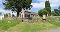 Llanddeusant Church - geograph.org.uk - 21991.jpg 640 × 340; 79 KB
-
 Llanddeusant church - geograph.org.uk - 2456078.jpg 640 × 480; 87 KB
-
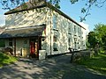 Llanddeusant Youth Hostel - geograph.org.uk - 610363.jpg 640 × 480; 126 KB
-
 Lloc Nant Gau - Nant Gau sheepfold - geograph.org.uk - 3542829.jpg 690 × 518; 169 KB
-

-
 Llwybr Cwm Sawdde Footpath, Twynllannan - geograph.org.uk - 3674899.jpg 690 × 518; 257 KB
-

-
 Llwybr Ffinnant - Ffinnant path - geograph.org.uk - 3691580.jpg 690 × 518; 256 KB
-
 Llwybr Ffinnant Path, Pontarllechau - geograph.org.uk - 3760383.jpg 690 × 518; 273 KB
-

-
 Llwybr Gorsddu Footpath - geograph.org.uk - 3542602.jpg 690 × 518; 255 KB
-
 Llwybr Tir Paun - Tir Paun footpath - geograph.org.uk - 3670069.jpg 690 × 518; 244 KB
-
 Llwybr Ty Grain Footpath - geograph.org.uk - 3542665.jpg 690 × 518; 273 KB
-
 Llwybr Wenallt - Wenallt footpath - geograph.org.uk - 3542689.jpg 690 × 518; 168 KB
-
 Llyn y Fan - geograph.org.uk - 3543132.jpg 690 × 518; 144 KB
-
 Llyn y Fan Fach - geograph.org.uk - 2569532.jpg 640 × 480; 59 KB
-
 Llyn y Fan Fach - geograph.org.uk - 2949639.jpg 1,024 × 680; 196 KB
-
 Llyn y Fan Fach - geograph.org.uk - 6228629.jpg 3,264 × 2,448; 2.29 MB
-
 Llyn y Fan Fach - geograph.org.uk - 6229228.jpg 1,935 × 1,244; 508 KB
-
 Llyn y Fan Fach - geograph.org.uk - 6237401.jpg 3,264 × 2,448; 2.93 MB
-
 Llyn y Fan Fach and Picws Du - geograph.org.uk - 3211950.jpg 2,112 × 2,816; 2.02 MB
-
 Llyn y Fan Fach from Bannau Sir Gaer - geograph.org.uk - 3211934.jpg 2,112 × 2,816; 1.29 MB
-
 Llyn y Fan Fach from Picws Du - geograph.org.uk - 2569501.jpg 640 × 480; 60 KB
-
 Llyn y Fan Fach from Picws Du - geograph.org.uk - 3211926.jpg 2,816 × 2,112; 1.29 MB
-
 Llyn y Fan Fach trout farm - geograph.org.uk - 2569556.jpg 640 × 480; 110 KB
-
 Llyn y Fan Fach ^ Bannau Sir Gaer - geograph.org.uk - 3751264.jpg 1,024 × 768; 127 KB
-
 Lone hawthorn on sloping field - geograph.org.uk - 3921935.jpg 1,500 × 1,000; 1.2 MB
-

-

-
 Milestone - Langadock 4 - geograph.org.uk - 4327600.jpg 480 × 640; 136 KB
-

-
 Moorland on Waun Lefrith - geograph.org.uk - 2143379.jpg 640 × 480; 68 KB
-
 Moorland with rushes near to Blaenllechach - geograph.org.uk - 3924423.jpg 1,500 × 1,000; 1,005 KB
-
 Moorland, Bryn Mawr - geograph.org.uk - 3666898.jpg 1,024 × 683; 511 KB
-
 Mountain Road near Bylchau Blaenclydach - geograph.org.uk - 3666877.jpg 1,024 × 683; 691 KB
-
 Mountain road on Mynydd y Llan - geograph.org.uk - 2455978.jpg 640 × 480; 52 KB
-
 Moving the Sheep, Llanddeusant - geograph.org.uk - 3646463.jpg 1,024 × 683; 929 KB
-
 Mynydd Llan - geograph.org.uk - 3906355.jpg 640 × 480; 41 KB
-
 Mynydd y Llan, Llanddeusant - geograph.org.uk - 3542594.jpg 690 × 518; 181 KB
-
 Nant Ffynnon Wen Stream - geograph.org.uk - 3542793.jpg 690 × 518; 196 KB
-
 Nant Lluestau meets Afon Twrch - geograph.org.uk - 456824.jpg 640 × 480; 144 KB
-
 Nant y Creigiau - geograph.org.uk - 3913270.jpg 640 × 480; 62 KB
-

-
 North of Ty-uchaf - geograph.org.uk - 2015741.jpg 640 × 428; 282 KB
-
 Northern downfall of Black Mountain from Waun Lefrith - geograph.org.uk - 2644055.jpg 1,500 × 1,125; 1.4 MB
-
 Old School - geograph.org.uk - 4362885.jpg 640 × 480; 63 KB
-
 Ordnance Survey Cut Mark - geograph.org.uk - 3607091.jpg 480 × 640; 104 KB
-
 Ordnance Survey Cut Mark - geograph.org.uk - 3607099.jpg 640 × 480; 114 KB
-
 Ordnance Survey Cut Mark - geograph.org.uk - 4362867.jpg 480 × 640; 144 KB
-
 Ordnance Survey Cut Mark - geograph.org.uk - 4362877.jpg 480 × 640; 124 KB
-
 Ordnance Survey Cut Mark - geograph.org.uk - 4362884.jpg 640 × 480; 105 KB
-
 Ordnance Survey Pivot - geograph.org.uk - 4362888.jpg 480 × 640; 102 KB
-
 Ordnance Survey Rivet - geograph.org.uk - 4362870.jpg 480 × 640; 126 KB
-
 Pant Twyn Gwyn - geograph.org.uk - 3920282.jpg 640 × 480; 64 KB
-
 Pant Tyle Gwyn - geograph.org.uk - 2954126.jpg 1,024 × 680; 227 KB
-
 Part of the summit cairn on Picws Du - geograph.org.uk - 2569467.jpg 640 × 480; 89 KB
-
 Path below Bannau Sir Gaer - geograph.org.uk - 2955345.jpg 680 × 1,024; 193 KB
-

-
 Path from Llyn y Fan Fach - geograph.org.uk - 3211964.jpg 2,816 × 2,112; 2.03 MB
-
 Path leading towards Llyn y Fan Fach - geograph.org.uk - 2143402.jpg 640 × 480; 57 KB
-
 Path towards Llyn y Fan Fach - geograph.org.uk - 3211936.jpg 2,816 × 2,112; 1.37 MB
-
 Path towards Llyn y Fan Fach and the Carmarthen Fans - geograph.org.uk - 3211942.jpg 7,215 × 1,837; 2.38 MB
-
 Pen Y Wern - geograph.org.uk - 3607105.jpg 640 × 480; 89 KB
-
 Pencarreg Farm - geograph.org.uk - 6228908.jpg 3,264 × 2,448; 3.05 MB
-
 Penwaun Crynfe - geograph.org.uk - 6123489.jpg 3,264 × 2,448; 4.3 MB


_-_geograph.org.uk_-_5973716.jpg)


_-_geograph.org.uk_-_3298108.jpg)


.jpg)


